A series on West Kootenay/Boundary place names
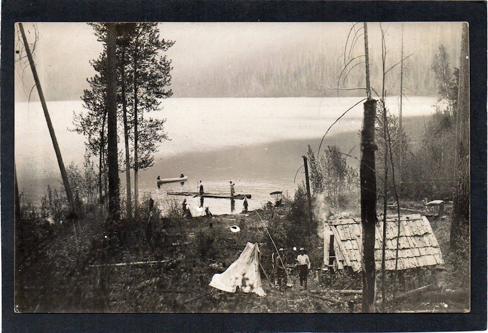
Whatshan is among the oldest place names in West Kootenay still in use, but its meaning is not clear. It was first mentioned in explorer James Turnbull’s diary on Aug. 6, 1865: “Camped at the junction of south branch pass with the columbia; the Indians call this stream What-shaan River.”
Walter Moberly’s 1866 map labelled a lake, along with the stream that drained into it, as Waatshaan.
Gilbert Malcom Sproat referred to the “Whatch-shan stream” in his Report on the Kootenay Country, dated Feb. 7, 1884. The present spelling first appears in George Dawson’s 1889 Report on a Portion of the West Kootanie [sic] District: “On the opposite side, however, are several streams, some of which may be called small rivers, and occupy notable valleys. Of these, Whatshan River, 10 miles and a half from the north end of the lake, drains, by one of its branches, a lake reported to be 18 miles in length.”
Other spellings have included Watshan and Watchan.
Whatshan is now applied to a lake, river, peak, and mountain range. The lake is just west of the north end of Lower Arrow Lake, the river flows southeast into Lower Arrow Lake, the peak is on the northwest side of Whatshan Lake, and the range is south of South Fosthall Creek.
“Whatshan Lakes” was adopted by the Geographic Board of Canada on March 21, 1924, but the form was adjusted to “Whatsan Lake (not Cariboo Lake) in the 1930 BC Gazetteer. It was reconfirmed as Whatsan Lake in 1953. It’s not clear when the spelling reverted to Whatshan.
As to the meaning, Cominco Magazine of August 1944 said it meant “white fish,” presumably in the Okanagan-Colville language, which “have always been plentiful in the Whatsan lakes.”
In Salishan Tribes of the Plateaus, James Teit recorded NEmi’mEltEm as the name of a Sinixt camp on “Caribou Lake, to the west of the narrows between the Arrow Lakes. The country around here was famous as a caribou-hunting ground.”
Although Teit offered no translation, in their First Nations Ethnography & Ethnohistory in BC’s Lower Kootenay/Columbia Hydropower Region, Dorothy Kennedy and Randy Bouchard write that “it seems clear to us that the term transcribed is actually nmimeltm which means ‘having whitefish’ in the Okanagan-Colville language.”
But as for Whatshan, they didn’t know what indigenous term Turnbull, Moberly, Sproat, and Dawson were all trying to transcribe.
The Whatshan post office operated from 1913 to 1917 with Isaac Penner as postmaster. The name is perpetuated in Whatshan Lake Road and Whatshan Lake Retreat.
WHITE’S CAMP
This Boundary mining camp was first mentioned in the Nelson Miner of April 16, 1892: “The sale of the City of Paris and the Lincoln mining claims in White’s camp at Boundary creek is reported as having been consummated.”
Henry White opened a general store in Rock Creek around 1885. The following year, he and a few other prospectors located White’s Bar on the creek and over three seasons reportedly recovered $50,000 in gold.
White later had claims in Camp McKinney before locating the Knob Hill in July 1891 — the first claim in Greenwood Camp, the future site of Phoenix. In September, he co-located the Lincoln in his nameksake camp, on Lot 791 of the Osoyoos land division, about 10 km southeast of Greenwood. It was closely associated with Atwood and Douglas camps.
According to the Midway Advance of Sept. 5, 1894: “For all practical purposes they are one and the same camp, and were formerly known as the Central camp. It has, however, been the practice to call the claims near Mr. White’s locations White camp, those around Mr. Douglas’ properties the Douglas camp, and the claims surrounding Mr. Atwood’s mines Atwood’s camp. It is almost impossible to say, however, where the one ends and the others begin, but it may be stated that the west end of the camp is Atwood’s (of which the Douglas may be said to form a part) and the east end’s White’s.”
(James Atwood was Atwood camp’s namesake, but it’s not clear who Douglas was.)
An application for a post office at White’s Camp was referred to the inspector on Nov. 15, 1899 and a report filed on Feb. 3, 1900 stated the camp consisted of “six families and about 100 single men.
“The City of Paris Gold Mining Company are developing their mines in the vicinity … [T]here is one hotel, two stores and several lodging houses at the site … The spur of the Columbia and Western Railway now being built from Eholt to Phoenix will probably be ultimately continued to White’s camp or Central camp as it is more generally known.”
The post office opened on June 1, 1900 with John A. McLoughlin as postmaster. It closed in 1902.
Henry White was involved in developing the City of Paris and Lincoln claims for years, and was also superintendent of the Lone Star and Washington properties near Danville, Wash. With the proceeds he built a “luxurious home” in Pasadena.
By 1908 he was in Prince Rupert, but his ultimate fate is unknown.