A series on West Kootenay/Boundary place names
Continuing our look at Grand Forks-area neighbourhood names, several of which have Doukhobor origins.
• Spencer Hill: We’ve previously studied this area west of the city, first mentioned in the Grand Forks Evening Sun of Feb. 21, 1905 and named for the Spencer brothers, who had a ranch on Fourth of July Creek.
Jonathan Kalmakoff’s Doukhobor Gazetteer (from which much of the information in this column is gathered) says it was also known among among non-Doukhobors as Doukhobor Hill, but to Doukhobors themselves, it was Sionskaya Gora (Сионская Гора), Russian for Mount Sion or Sion Hill, a reference to the Biblical Zion.
Spencer Hill was officially adopted as a geographic name in 1977. It’s perpetuated in Spencer Road, Spencer Hill Orchard, and Spencer Hill Cottage Brewery.
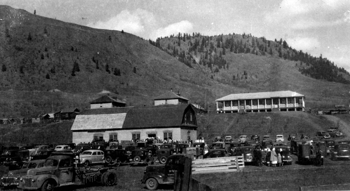
• Fruitova/Fruktova and Sion: When Doukhobors from Saskatchewan arrived in 1909, they bought 2,700 acres of land in West Grand Forks, naming the area Dolina Fruktova (Долина Фруктова), Russian for “Valley of fruit.”
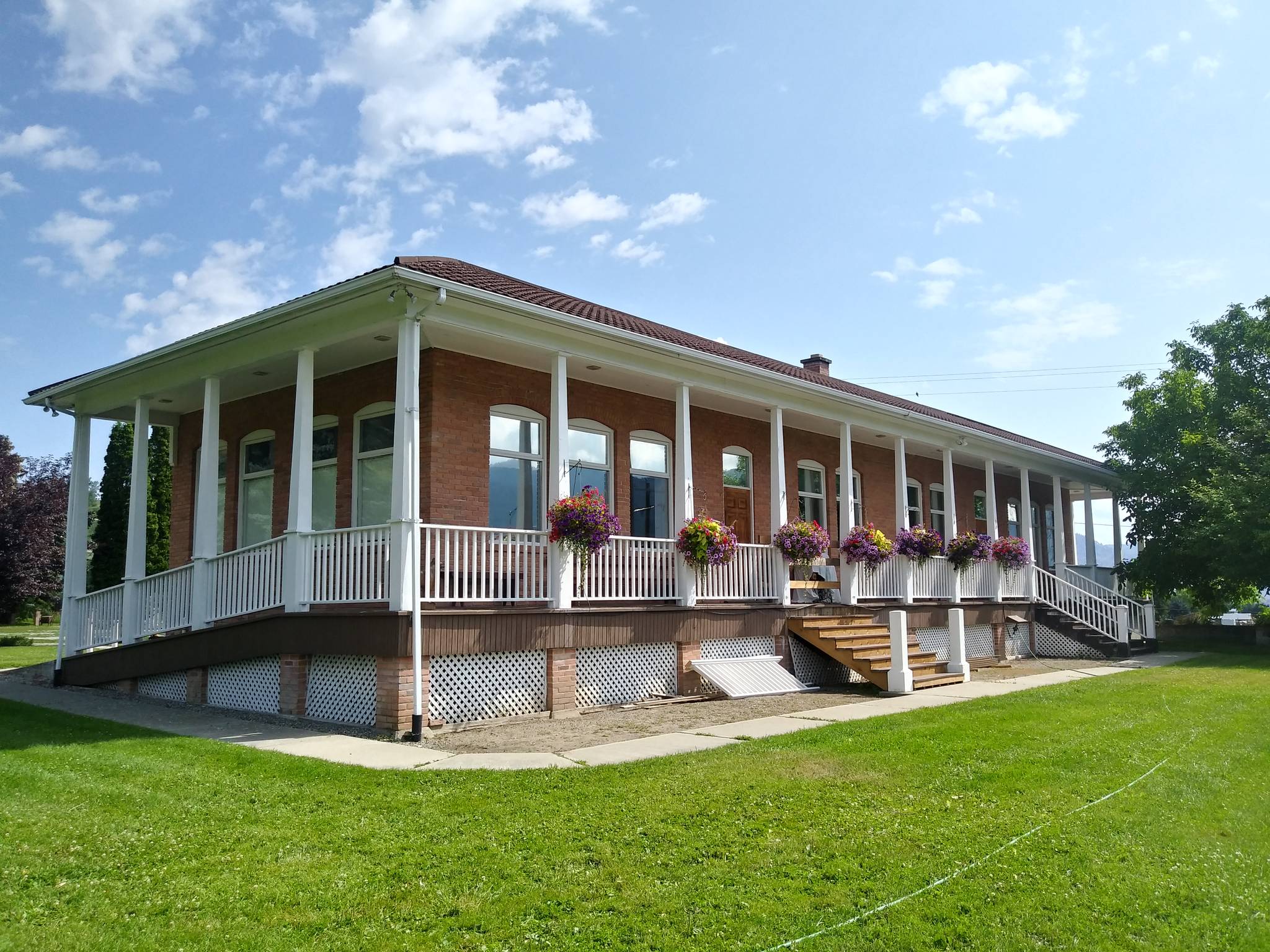
Later it became Fruktovoye (Фруктовое) and then Fruktova (Фруктовa), and was also transliterated as Fruitova, the name of the school district that operated from 1929-49. The old Fructova school is now the Boundary Museum.
After 1928, the area was better known as Sion (Сион) because of nearby Sionskaya Gora. The name is perpetuated in Sion Frontage Road and the Sion Improvement District.
Today Sion/Fruktova could be said to stretch from North Fork Road in the east through Spencer Road in the west, mostly on the north side of Highway 3, but including the USCC hall, cemetery, and flour mill.
• Khristovoye/Outlook: This area in the Hardy Creek/Newby Creek valley west of Grand Forks was named Dolina Khristovaya (Долина Христовая) by community Doukhobors, Russian for “Valley of Christ.”
It later became just Khristovoye (Христовое), although the name fell out of use by the time the communal lands were sold in the early 1960s. The Outlook school, named for the breathtaking view, operated there from 1917-49. Outlook Road perpetuates the name.
• Ubezhishche: Named in 1909 by community Doukhobors who bought 550 acres along July Creek. Ubezhishche (Убежище) is Russian for refuge or hideaway. The name fell out of use when the communal lands were sold in the early ‘60s.
• Chistyakovoye: Independent Doukhobors settled in the Carson area between 1937 and 1943 and named the area after leader Peter Chistiakov Verigin. The neighbourhood corresponded with a local branch of the Union of Spritual Communities of Christ of the same name. It was also called Chistyakovka (Чистяковка).
• Norsan: This was a Russianization (Норсан) of Nursery, a farming area east of the city that we looked at last week. Between 1937 and 1943, 30 community Doukhobor families from Saskatchewan settled there, later joined by independents. The name is no longer in use.
• Hardy Mountain: Previously covered in this series. The mountain, northwest of the city, was named by 1897 for the Hardy brothers, Thomas, Neil, and Edward who arrived in the Boundary between 1893 and 1901 and had a farm at the foot of the mountain. The name is perpetuated in Hardy Mountain Road.
• Manly Meadows: East of the city, between Nursery and Gilpin. It belonged to founding Grand Forks mayor John Manly, who reportedly extracted a high price for the land from the Great Northern Railway after they crossed his right-of-way in their haste to complete their line.
Manly swore out a warrant against the railway for trespassing before they agreed to buy the property on his terms. H.M. Brinkman bought the land from the railway in the early 1930s and sold it to Riverside Seed Farms in 1942. They in turn sold it to Tony Lodder in 1962, who sold it to Norman Stauffer.
The name is unofficial but was in use by 1931 and is perpetuated by Manly Meadows Road.
• Ruckle and Henderson’s Addition: Otherwise known just as Henderson’s Addition, it was laid out by 1907, but its location is murky. J.B. Henderson, the likely namesake, was a builder and architect.
• McNee’s Addition: Platted by 1906, although its location is unclear. The namesake was presumably William McNee, a Grand Forks alderman in 1904.
• Carter’s Addition: Laid out prior to 1910. Both location and namesake are unknown.
We’ll finish looking at Grand Forks neighbourhoods next week.
— With thanks to Jon Kalmakoff, Sue Adrain, and Laura Lodder