A series on West Kootenay/Boundary place names
A close study of old maps will often reveal little-known or briefly used names.
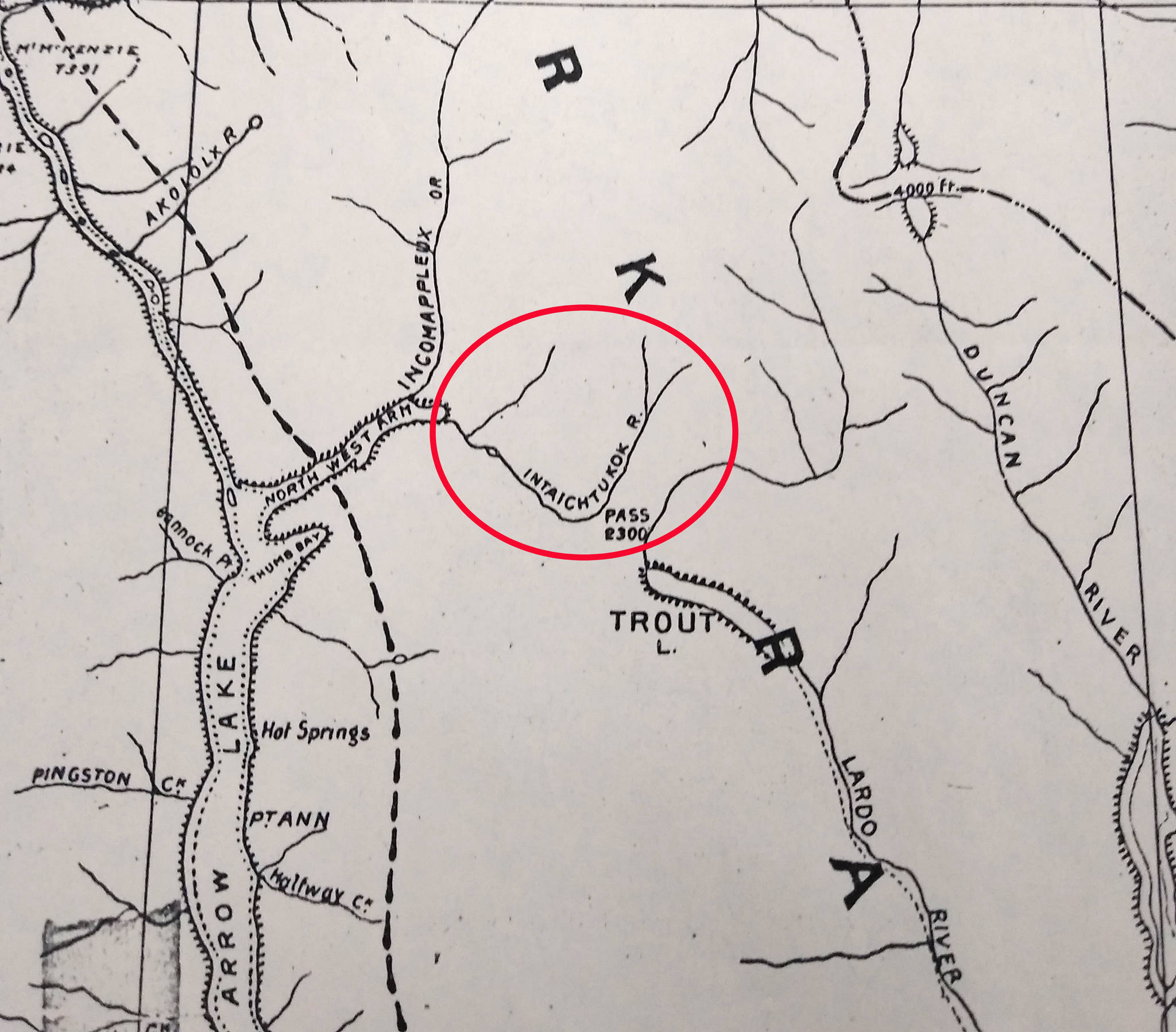
For example, Joseph Trutch’s 1871 map of British Columbia shows a stream between Trout Lake and the northeast arm of Upper Arrow Lake called the Intaichtukok River. He was presumably transcribing a Sinixt name, but which one is unclear. The name also shows up on John Keen’s Map of Kootenay, published in 1892, which shows the river flowing south from the east end of Upper Arrow Lake and then turning northeast and branching off in two.
The only other published use of the name was an item in the Revelstoke Kootenay Star of April 23, 1893: “It is said that some of the mining capitalists stopping at the landing [i.e. Thomson’s Landing, later known as Beaton] have been figuring on erecting large sampling works at the mouth of the Intaichtukok Creek, where there are falls sufficient to run any amount of machinery. These falls are about 300 yards from the hotel.”
We can guess that the Intaichtukok was what’s now called Beaton Creek, or perhaps a combination of Beaton and Pollman creeks.
Meanwhile, a Canadian Pacific Railway map of BC lake steamer routes and connections dated Dec. 8, 1909 shows a couple of curious places on Upper Arrow Lake: on the west side, almost directly opposite Makinson’s Landing, is Adolf’s Landing.
Who was Adolf? Arrow Lakes Historical Society archives technician Kyle Kusch found the answer.
“According to the late Pat Cameron in the intro to the Arrow Park section of Whistle Stops Along the Columbia River Narrows, Adolf’s Landing would refer to Gus Adolph, one of the earliest pre-emptors here. Miles Yingling and family preempted first in 1901, followed by Alex Graham in 1902 and Gus Adolph around this time as well.
“We know the correct spelling is Adolph (not Adolf) based upon a letter he sent to the provincial police in Nakusp to request a hunting license to shoot game on his ranch, which is listed as Lot 979 of the Arrow Park subdivision. Eventually, he sold his land in portions to the Marsland and Rogers families. The Marslands arrived at Arrow Park in 1911, so we know that Adolph was gone around that time.”
Gus Adolph (1871-?) shows up on the 1911 census living in a hotel at Edgewood. He gave his occupation as a labourer in a lumberyard and indicated he came to Canada from Sweden in 1891. It’s not clear what became of him.
The name Adolf’s (or Adolph’s) Landing wasn’t around long — Kusch says he’s never seen another reference to it. But Gus Adolph soon popped up again.
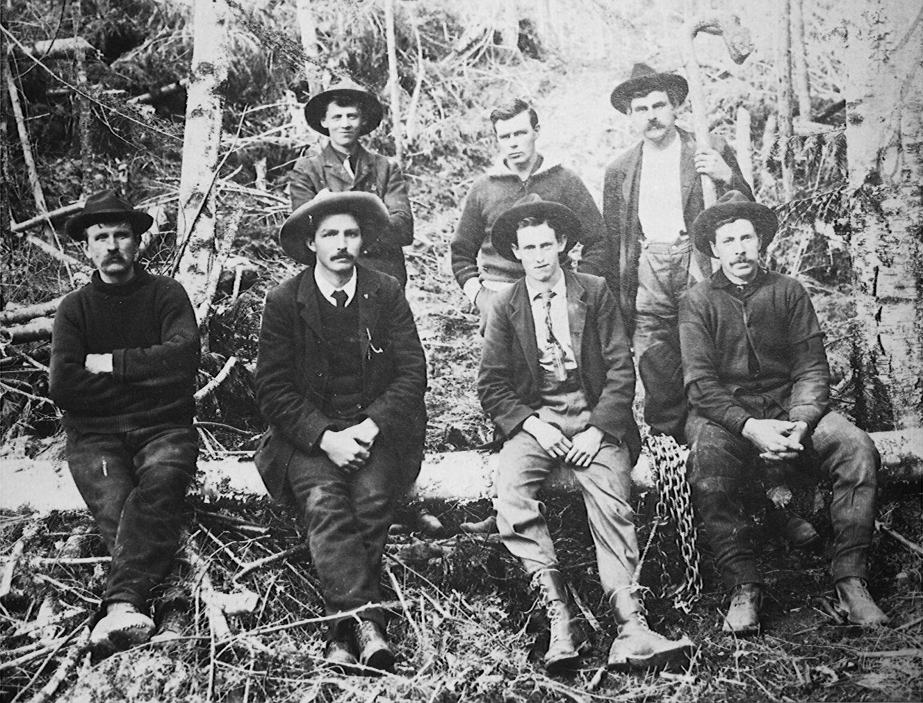
A woman from Ontario asked the archives about a photo they had of her great aunt, Effie Hyde, who married Burton pioneer Lance Porter. As Kusch was updating the photo database, he stumbled across a photo of a 1908 logging crew that included Porter.
“Sure enough, one Gus Adolph is in the bottom left of the image. This is the first time I’ve seen an image of him. Oddly enough, the photo also has a much more famous landing namesake, George Makinson, at top left.”
A little south of Adolph’s Landing, also on the west side of the lake, but north of Grahams Landing, the 1909 map showed a placed called Yinglings. Miles Yingling (1864-1927), mentioned above, was the namesake of this place — which joins Ymir and Yoder as one of the only three West Kootenay place names that start with Y.
Finally, the 1909 map shows a spot further south on the lake’s west side called Christie. Now known as Oatscott, it was previously covered in this series, and was named after Alex Christian, or Christie (1873-1924), a prominent Sinixt man who owned land there.
Christie sold his property to Indian army veteran William James Lascelles (1858-1921) and the names Christie Landing and Lascelles Landing were used interchangeably for a few years until Lascelles renamed his property Oatscott (or Oatescott).
The Arrow Lakes Indian Reserve, established in 1902, was later known as the Oatscott Reserve, despite the fact it was not a spot traditionally used by the Sinixt.
Previously the first known use of the name Christie Landing was from 1913, but this map shows it was used at least four years earlier.
— With thanks to Kyle Kusch