Lord willing and the creek don’t rise is the state of the union in the Beaver Valley.
Even though the heart of spring runoff is still one month away, eyes are beginning to turn to one of the region’s trouble spots for flooding: the Beaver Creek.
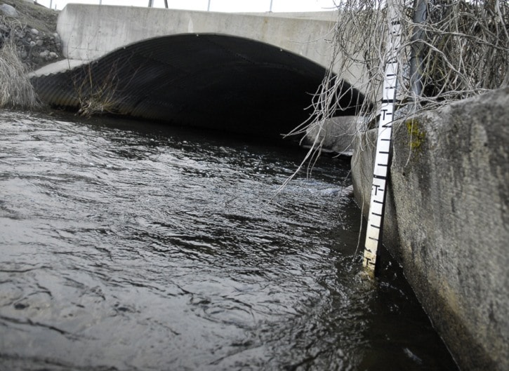
The recent rains have swelled the waters of the creek as it makes its way through the village down to the Columbia River, putting creekside folk into a wary state of existence.
Historically the creek jumps its banks on properties that border it — including Creekside Community Park in Fruitvale — in mid May, but the current height of the creek isn’t a concern just yet, said Village of Fruitvale chief administrative officer, Lila Cresswell.
“About this time of the year we get a bit of a rise due to rain and low level snow melt,” she said.
The weekend rains likely brought some flash flood issues, said Dan Derby, deputy regional fire chief with the Regional District of Kootenay Boundary, but so far nothing has been reported.
He said it was important for people to monitor their own drainage systems right now, as well as catch basins, to make sure they are clear.
“We live in an area that is prone to some low level flooding in some parts of the region, but in saying that, it doesn’t happen every year,” he said. “That could change in the coming weeks depending on the weather. However, at this point we are not very concerned.”
The highest risk area in the Greater Trail region continues to be Fruitvale where homes border Beaver Creek, he said, as well as the Kettle River area (through Grand Forks) and Christina Lake on the regional level.
The village checks the level of Beaver Creek daily when it begins to look like the water level is rising, said Cresswell, with gauges installed at the Columbia Gardens Road Bridge and at Marsh Creek. Additional point people are also measuring on the creek at either end of the village.
“When they see it begin to get close to their property levels they call the village and we begin the watch,” she said.
The flood watch information is then reported to Derby. A flood falls under the regional district’s emergency management plan, and initiates a series of responses once activated.
The plan in place includes hundreds of sandbags on ready, with sand piles and burlap bags on hand to create more in the village, with hundreds more sand bags also in place on a regional district level.
Last year the City of Trail received a shipment of 4,000 sand bags from the province, adding to the 4,000 bags already stockpiled in the city’s inventory to cover Gorge Creek and Trail Creek.
With all of the preparation in place, there has not been a major flood in Fruitvale since 2007, said Cresswell, but down near the village’s cenotaph the waters usually rise and cover lawns that border the creek, submerging around one quarter of the local resident’s land for a few weeks.
“If you live in the creek area you pretty much sand bag at some point every year,” she said.