The Federal Electoral Boundaries Commission heard an outpouring of concern from Greater Trail residents and their riding last spring, they just didn’t listen.
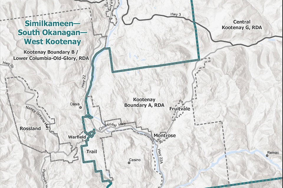
If you live in Rossland, Warfield, Rivervale, Genelle, Area B and Castlegar, in the next federal election, you will be voting in a completely different riding than those in the City of Trail and Beaver Valley.
Trail Mayor Colleen Jones said she was clear when she shared concerns over the commission’s initial proposal to divide the municipalities and areas.
“The federal boundary changes make no sense. The Beaver Valley communities of Montrose, Fruitvale and Area A are part of a corridor that included Rossland, Warfield, Trail and Area B.
“We are connected communities of the Lower Columbia region and we must remain as one.”
The commission first proposed to bisect Greater Trail, leaving Montrose, Area A and Fruitvale to the eastern right, and Trail, Warfield, Rossland to the western left.
“They popped that on us in the spring, and it was whoa hold on here,” said Fruitvale Mayor Steve Morissette. “But they didn’t listen at all. They didn’t understand that it was from Rossland straight to Fruitvale, Beaver Valley. Part of their thing is to keep communities of interest together, which is what we are.”
The commission then changed its “proposal” back to a riding that looked to keep Greater Trail intact.
Yet, in its final report the commission drew a line around Trail and Tadanac, bypassing the nearby communities of Genelle, Rivervale, and Warfield, and linked everything east of West Trail to the newly dubbed Columbia-Kootenay-Southern Rockies riding that now stretches from Trail to Fernie.
“To be honest, I was shocked, because that wasn’t even part of the discussion before,” said Jones. “Trail wasn’t included, and we were trying to keep Montrose, Fruitvale and Beaver Valley in with Trail and Rossland, so we didn’t want to see them leave, and then we (Trail) ended up leaving.”
Morissette says he was hopeful the changes would not take effect after the Beaver Valley community rallied and sent a petition with more than 1,100 of 1,700 voters’ signatures to the commission, and South Okanagan-West Kootenay MP Richard Cannings raised several objections at the final hearing.
“The process is flawed,” said Morissette. “They didn’t even follow their process where they have consultation. They had consultation a year and a half ago when there was no change in our boundaries.”
In the commission’s final report, it recognizes, “There is force to Mr. Canning’s submission in respect of the Castlegar and Trail neighbourhoods of communities, and his suggestion can be given effect to strengthen communities of interest without creating undue variance between Similkameen-West Kootenay and Columbia-Kootenay-Southern Rockies.”
Yet, the commission did not appear to know which communities fell under the umbrella of Trail or those of Castlegar.
“Accordingly, by this response, we reconfigure the report’s boundaries for the Castlegar and Trail areas by locating the Castlegar neighbourhood of communities within the Similkameen-West Kootenay electoral district, and locating Trail and its neighbour communities to the east within Columbia-Kootenay-Southern Rockies,” the report notes.
The Electoral Boundaries Commission made a similar attempt to drive a political boundary wedge between Beaver Valley and Trail in 2012 in what has traditionally been an NDP stronghold.
In the next federal election, Trail and Beaver Valley will be cut out of its NDP riding led by Cannings and put into a potential Conservative riding currently led by MP Kootenay-Columbia Rob Morrison.
“We’ve never been in this area before with the federal ridings, so I really don’t know what the impact will be,” said Jones.
“Trail has always been in this region with Rossland, Warfield and Castlegar, but even with these changes, we are not going to change how we work together. We still have the same interests, the same regional focus, it’s just going to look different.”
The 2021 decennial census reported an increase of about 600,000 residents to a current population of five million. The number of electoral districts province-wide will increase by one to a total of 43, which translates into about 116,000 people per district. This is called the electoral quota.
According to the census, the Kootenay-Boundary electoral district had a population of almost 112,000, while South Okanagan-West Kootenay came in at 109,000, well within the 25 per cent plus or minus the quota uses to ensure adequate representation.
“My concern over this will be, are we as rural B.C. … still going to have the same voice when we move to the new riding,” queried Jones. “Or will we have more of a voice because we are not so rural, because we have more urban communities?”
While the process has been rife with confusion and frustration, the decision is final, and both Morissette and Jones are hoping for the best.
“At this point, I think we are at the end of the process, that’s what they decided,” said Morissette. “It’s unfortunate that Rossland and Warfield are not part of us anymore. That’s the big thing, we are trying to keep the Greater Trail area together, that’s not going to be the case for the federal riding, and whether that will make much difference, who knows.”
The Chief Electoral Officer will use the electoral boundaries described in the report to draft the representation order, which should become official in September 2023.
The new electoral map will be used in the next general election.
Read: Beaver Valley residents respond to electoral boundary changes